Owens Valley
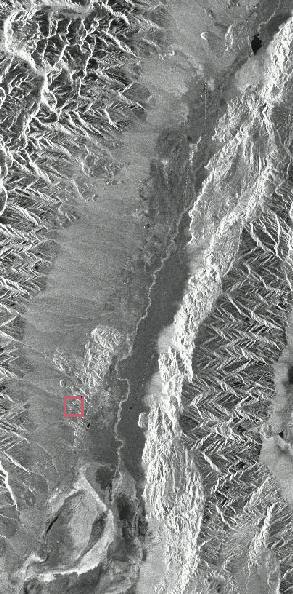
The Owens Valley is a long, narrow slice of high desert in eastern California. In this satellite photo (a synthetic aperture radar image), the southern half of the valley is seen ensconced between the Sierra Nevada (on the left) and the Inyo Mountains (on the right). My neighborhood is in the area marked by the colored square, at the outskirts of a rocky region that appears light and mottled in the photo.Although this part of the valley only sees an average of roughly five inches of rainfall per year, runoff from the Sierra Nevada provides copious amounts of water. An aqueduct diverts most of that water for the purposes of a large city 175 miles to the south, thereby sucking the life out of the Owens River (visible as a light serpentine line going down the east side of the valley) and Owens Lake (the blotch it leads to at the bottom of the image).
California (and thus the Owens Valley) is part of a large territory which the USA, driven by the notion of manifest destiny, took from Mexico by force in the 1840s. Some 60 years later, lust for growth would drive the aforementioned large city to secure title to much of the land in the valley for the water rights. To keep any would-be private owners of neighboring lands from laying claim to the water, the federal government added large areas in and around the valley to the Inyo National Forest in 1907. You and I might consider it irregular to declare treeless desert terrain part of a National Forest, but President Theodore Roosevelt and Forest Service director Gifford Pinchot deemed that and other details of law less important than helping a city that was hell-bent on growth. The city to the south got the water and the growth it asked for, and now enjoys impressive levels of smog and traffic.
Instead of big-city amenities, the Owens Valley offers peace and quiet, dark starry nights, wildlife, and natural beauty. Although the history of the area's exploitation is a sad one, most of us who live here are grateful that almost all of the region is now off-limits for development. The Owens Valley is in Inyo County, which has more land area than the state of New Jersey but fewer than 20,000 residents. (For European readers: Inyo County has slightly more land area than Sicily.)
Although the natural features are the main attractions in the area, there are a few settlements as well. In alphabetical order: Big Pine has the endearing feature that you only have to slow down to 35 when driving through, as opposed to Bishop which has traffic lights, a speed limit of 25, and goes on for a lot longer. Darwin isn't in the Owens Valley, but it's not too far away and is a great place to visit if, like me, you feel that decaying cars and machinery have more visual appeal in a desert setting than most anywhere else. Darwin used to have a remarkable web site which was under revision last I looked. Independence, the county seat, has two of the nicest old buildings in the valley: the Inyo Covnty Covrt Hovse and the Winnedumah Hotel. Lone Pine, my home, has 2200 residents and the only traffic light in a 50 mile radius; click here for an interactive map of Lone Pine (from the US Bureau of the Census).
The neighborhood I live in can be seen in the (optical) photo below, taken August 23, 1998. The area shown is slightly less than one square mile (and represents only a portion of the colored square in the Owens Valley satellite photo above). Terrain is approximately 4500' (1370m) above sea level.

Tom Ace
return to Tom's home page
Owens Valley SAR image Copyright © Deutsches Zentrum für Luft- und Raumfahrt; used by permission. The original larger version on the DLR web site shows more detail.